UAV-MapVQA dataset
336K multiple-choice questions over 14,000 UAV image–map pairs. Each one needs both views: the map knows which building is which, and only the UAV image shows what is there now. Try a few yourself.
One question, two map representations
Each sample is a UAV image, the map of the registered area, a question, options, the answer and an optional visual prompt. The map comes in two synchronized versions built from the same OpenStreetMap data; both share the UAV images, questions, options and answers.
UAV-MapVQA-Visual
A north-up raster in OpenStreetMap Carto style, slightly larger than the UAV footprint so the footprint cannot be found from the map border. Road classes differ in colour and width; buildings, land use, water and railways have distinct fills. Map-side options are drawn on it as outlines and letters.
See the Visual examplesUAV-MapVQA-Tabular
The same window serialized as entity tables: roads, buildings and areas, and road junctions, with tags, normalized boxes, centroids and orientations, so names, types and topology are explicit rather than read off pixels. Map-side options become anonymous row keys or coordinates. Dense scenes need up to 2.7× more tokens.
See the Tabular examplesUAV-MapVQA-Visual examples
Real questions from Test-3.2K, 20 per task. The model sees the map and the UAV image with the question's visual prompts. Answer a few yourself: choose an option, then compare with people and the models.
Prompt sent to the model
A stratified sample of 20 questions per task from Test-3.2K, the 3,200-question evaluation set. Keys: A–D choose, Enter checks, ← and → move between questions. Open the full Test-3.2K viewer
UAV-MapVQA-Tabular examples
Five questions per task, the same ones as in the Visual examples, with the map image replaced by the full entity tables of the same tile. Every map entity carries its GPS position. The UAV image keeps its visual prompt. Rows the question refers to are highlighted here for the reader; the model gets the plain tables.
Tables from the paper's serializer, with GPS columns added for this page. Row keys (b12, r3, a1, …) are anonymous and assigned in table order, never OSM ids, so a row cannot be looked up elsewhere. For unmapped-building questions the tables come from the edited map, as for the model.
Built to be answerable, and hard to shortcut
Answers come from deterministic geometric predicates on the verified scene graph. A question is kept only if every decision margin exceeds three times the image's registration error.
Verified anchors
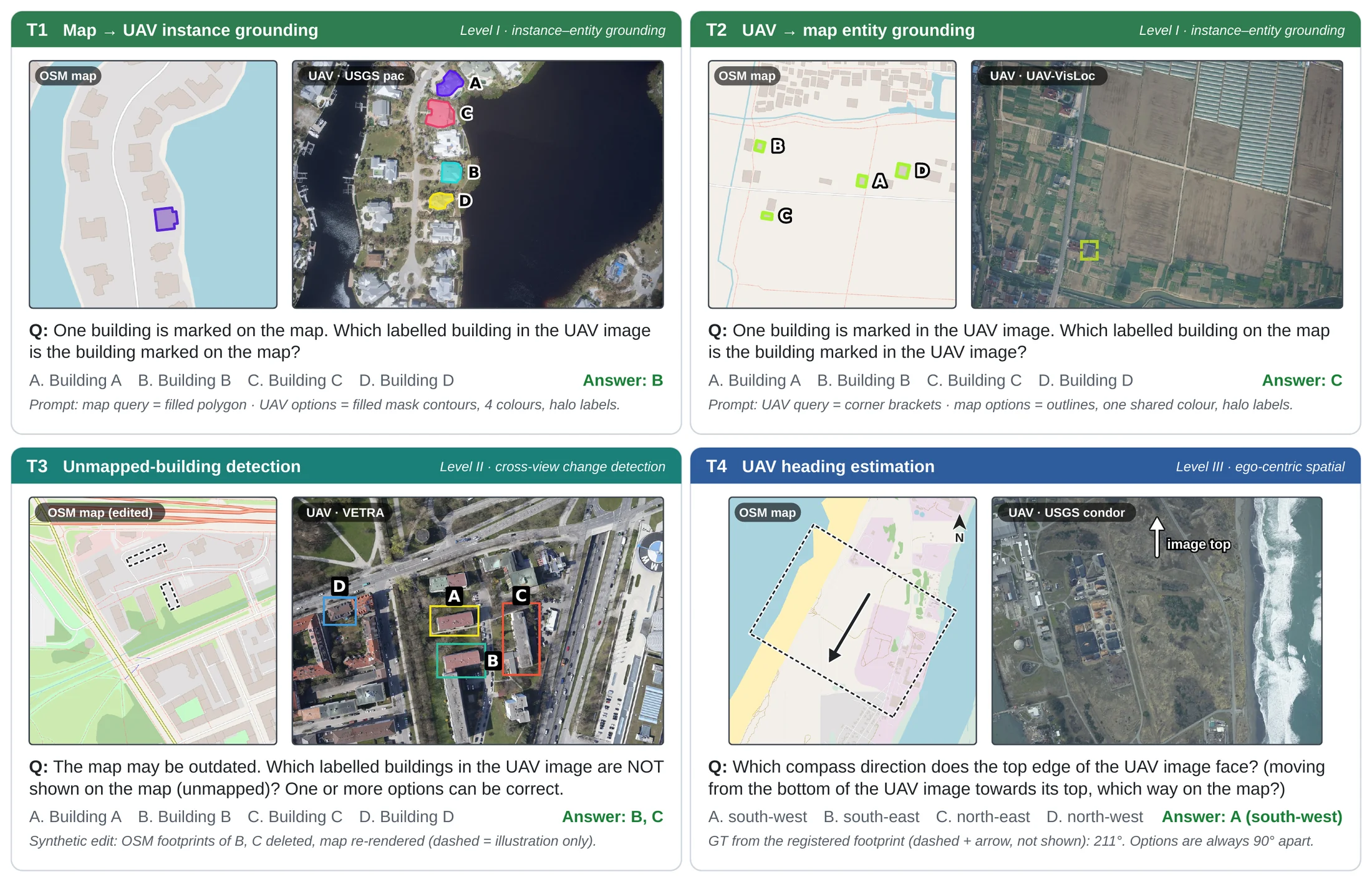
T1–T3 draw the query and all four options from the human-verified building pool. T3 deletes the footprints of one to three labelled options, plus up to two unmarked decoys, before re-rendering the map. Vehicles are lifted onto the map only if they are car-sized.
Plausible distractors
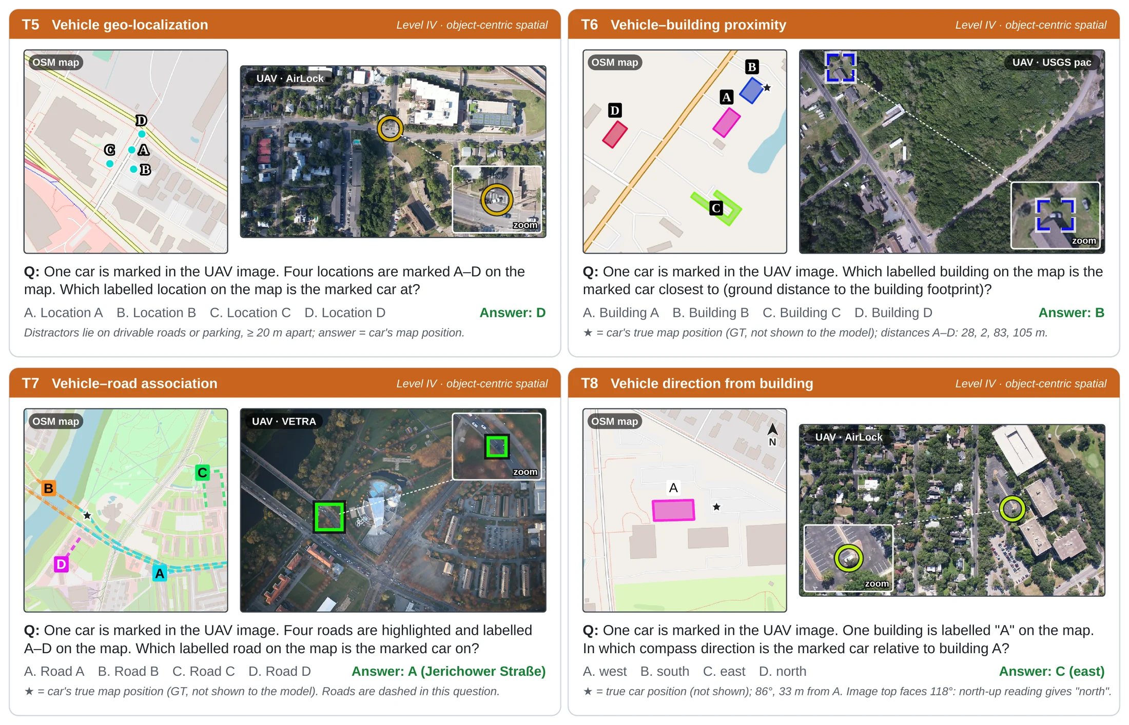
Locations at least max(20 m, 5× error) away for T5, other verified buildings for T6, other drivable roads including one of the same class for T7, and the remaining compass directions for T8. Targets and candidates are closed ways of at least 100 m².
Randomized prompts
Marks use two styles, colour masks and numeric tags, with colour, fill, line width, shape and option order randomized and balanced. Every mark passes a contrast check, and UAV images are never rotated north-up, so "pick the largest building" stays near chance.
Quality control via human verification
People check the data at every stage where an automatic step could be wrong: the registration, the cross-view correspondences, the generated questions, and finally whether the questions can be answered at all.
Registration
Every flight was replayed with its projected map overlay; frames with drift, a wrong homography or a misaligned basemap tile were discarded. Six annotators georeferenced 1,440 frames by hand: median error 1.9 m.
Correspondences
The building pairs behind every question were inspected and shifted or ambiguous pairs removed. An end-to-end audit of 20% of the images found 98% correctly matched.
Questions
1,200 sampled questions were rated in a dedicated web tool against four criteria, below.
Answerability
Six students not involved in building the dataset answered 240 questions each: 94.8% correct, one minute per question.
Ratings of 1,200 sampled questions
each question rated by a reviewer as accept, minor fix, major fix or reject
| Criterion | A question passes when |
|---|---|
| Clarity | The marks and labels are legible and no label hides another option. |
| Unique grounding | Exactly one option is supported by the joint image–map context, and answering needs both views. |
| Prompt correctness | Every mark picks out one real, distinct building, road, location or car. |
| Answer correctness | The ground-truth answer is right. |
Task cards from the paper
One real question per task in both versions. Dark dashed lines and stars mark the ground truth for the reader; they are never shown to the model.