Cuniua River, Deni lands, Tuesday, February 20th
11:10h: We've just picked up Liberato as he canoed down the river. He is the engineer Specialised in agriculture that ministered the cartography and topography workshops to the Deni as part of our Demarcation Project. I first met Liberato, about 6 months ago.
15:13h: Amisharu means thank you in Deni language. Todd thanks Zena, a Deni from Sumauma, in Zena's language with his characteristic Canadian accent. It's a moment of absolute cultural interchange.
The Sumauma village has been built on a high portion of terra firma. After eight days of sailing, I must confess that my legs were heavy when I reached the end of the steep hillside that leads to the houses.
As always, we have been received with open arms and smiles. As always, I've been amazed that these people immediately recognize the human essence we share, despite the different traces and strange machines we carry.
20:31h: Just had dinner. Iracema is surpassing herself. Fried balls of manioc filled with cheese, pumpkin soup and cupucacu (traditional Amazon fruit) mousse.
Going to bed soon, as tomorrow we have a busy day with the Deni.
Deni lands (Sumauma), Wednesday, February 21st
7:00h: I've just woken up and greeted by a dozen Deni Indians. As I looked at their good-natured eyes and felt their wish to be with us I've gave them a big smile.
8:20h: We are at Kuaman's house. He is a zupinehe (shaman), a key position in the Deni society. Kuaman is known in all Deni villages and is one of the strongest links between the Cuniua and Xerua villages. Respected and respectful, he is a man of few words. When he speaks, all heads turn to him and people fall silent. More than a leader, he seems to be a permanent inspiration.
Accumulated over centuries of life in the forest, the Deni religious knowledge is transferred from father to son generation after generation. Kuaman is married and has four children. He has identified the little Raman, an adorable boy that seems to be everywhere at the same time, as his successor. He will take over Kuaman's duty when he is gone, to play his political and spiritual role and give long life to the Deni tradition.
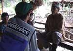
9:00h: A meeting was helded at Kuama's house with leaders from all the Deni villages and with Henrique, 35 who works at PPTAL, the PPG7 funded program that aims to demarcate and support 160 indigenous lands within the Brazilian Amazon.
Impressed by the meeting and the quality of the technical capacity of the Deni, Henrique supports the demarcation of Deni lands in 2001.
10:38h: A cartography and topography workshop is conducted with help of Vaisuvi, a Deni from Visagem village, he measures the distance between the two points while a third Deni sets up the beacon.
They handle the survey equipment with care and are shy to show their topography knowledge to the cameras. It's amazing to see that they can read angles, degrees and minutes and turn such complicated numbers into practical actions.
During the teaching process, we had to consider the Deni characteristic of collective knowledge. As they don't write, they keep what they learn by sharing the information among them", Liberato says, taking up his teacher posture.
Another element we explored was the talent for and habit of hunting. To hunt an animal in the forest is an activity that demands high level of precision, as does dealing with the topography".
The sunset and the sunrise were the main references used to teach the concepts of North and South. Only then azimuthally and angulations became the issue. It's been an extensive learning process and the results are visible. "It was hard, but it was good. I will never forget what I've learned and I will accompany the team when they demarcate our lands", Vaisuvi told me.
14:45h: Zena and Vaisuvi took us for a canoe ride to a neighbouring igapo. The beauty of the forest and my smiling companions made me forget about the micuins.
By the time the sun was vanishing on the eastern plain, Liberato held a review of the workshops. First the Deni talked about maps. They started with a world map and focussed down until the issue became the map of the Deni territory. Then it was the time to talk about latitudes and Longitudes, and I realised that by now the Deni have better geographic and geodesic understanding than I do.
20:57h: Its been a great and productive day. We should leave Sumauma tomorrow early afternoon and sail up the Cuniua River, until the mouth of the Arua.
Cuniua River, Deni lands, Thursday, February 22nd
13:00h: The Comandante Savio sails up the Cuniua River. We have about 20 Deni people onboard. Most of them are just taking a ride with us up to an igarape (an igarape is a backwater of a main river.) They are spread all over the boat, looking at us with curiosity, observing our gestures and activities. It feels pretty strange and sometimes even uncomfortable to be stared at all the time, no matter if you are typing in your computer, having a cup of tea or just reading on a hammock. But I guess they feel the same when we gaze at them cooking, paddling a canoe, cleaning their hunt or any other of their normal routines.
Tomorrow Carnival starts. If you ever heard about Brazil, you probably know what Carnival represents in this country. Huge parties on the streets, 99% of media attention, profits for beer companies, free music and happiness. Not in this place though. This is Brazil without Carnival.
16:58h: There are no piuns around!!!! We are having our first piun break in five days. Sun is shining, but the temperature is mild. One day is never like the other in the heart of the Amazon.
Ike, our doctor, made an interesting comment on the Deni health. He said that their average protein level is quite high, higher than the Yanomami people. There is a link between this factor, which means healthier kids, and the demarcation of lands. The hunt is a very important component of the Deni diet. To guarantee sustainable hunt, they need extensive tracts of lands. Therefore, the demarcation is fundamental to maintain the Deni diet in today's level.
Tomorrow before the sunrise we will leave to a practical demarcation lesson. The Savio will moor at the mouth of the Arua River, a tributary of the Cunia. Accompanied by 8 Deni leaders, we will sail up the Arua until we reach P18. (P18 is one of the boundary points that the Deni have surveyed. It will be one of the reference points for the physical demarcation.)
P18 is located on the south-east border of the Deni territory. To get there, we will travel for at least 3 hours in the speedboats and walk for a couple of hours in the forest. Once there, we will set up a camp and the Deni will practice what they have learned in the map classes and workshops.
It will certainly be the most original, interesting and exciting Carnival I've ever had.
20:19h: Just finished to put together all the stuff for tomorrow. Piles of plastic and dry bags as we will probably need it to keep food, equipment and everything else out of water reach. Arua River. Here we go!!